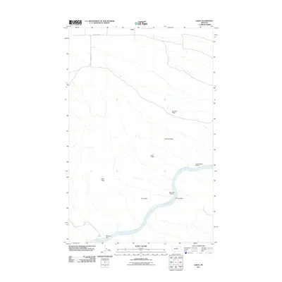
2011 Map of Leroy
USGS Topo · Published 2011About this map
Leroy sits at the northern edge of this high-plains landscape in Blaine County, where the terrain is defined by long, parallel elevations and the winding course of the Missouri River. The geography reveals a series of distinct ridges, including Barnard Ridge, Red Rock Ridge, and Lake Ridge, which trend toward the river valley. Along the water's edge, the map identifies specific riverine features such as Chimney Bend and Greasewood Bottom, suggesting the localized importance of these floodplains and landmarks for navigation or ranching. Access to this remote region is provided by Ervine Ridge Rd and Cleveland Rd, connecting the scattered settlements to the broader Montana territory. Farther south, McGarry Bar marks a notable point on the river, while names like Coal Ridge hint at the underlying geology that has shaped the local industry and settlement patterns of the northern Missouri River breaks.
Find a feature on this map
13 named features on this map. Tap any name to fly to it.
Don’t see what you’re looking for? This feature index may not catch every label — zoom into the map to look around manually.
Map Details
Editions of this 2011 Leroy Map
This is the sole edition of this map. No revisions or reprints were ever made.
Other maps of this area

1954 · Taffy Ridge
USGS Topo · 1:24,000

1954 · Bird Rapids
USGS Topo · 1:24,000

1954 · Leroy
USGS Topo · 1:24,000

1954 · Gallatin Rapids
USGS Topo · 1:24,000

1954 · Lewistown
USGS Topo · 1:250,000

1959 · Lewistown
USGS Topo · 1:250,000

1964 · Ragland Bench
USGS Topo · 1:24,000
1985 · Nolan Reservoir
USGS Topo · 1:24,000

1985 · Woodhawk Hill
USGS Topo · 1:24,000
1985 · Sandpiper Reservoir
USGS Topo · 1:24,000