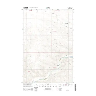
2014 Map of Leroy
USGS Topo · Published 2014About this map
The Missouri River carves a deep path through the broken rangeland of central Montana, defining the boundary between Blaine and Fergus Counties. This landscape is characterized by a series of prominent high points and drainage bottoms, including Pendell Ridge, Barnard Ridge, and the distinct Coal Ridge. The river itself features the challenging Lone Pine Rapids and significant riparian flats such as Box Elder Bottom and Greasewood Bottom, which have historically served as critical landmarks for navigation and land management in this cattle-ranching region.
Find a feature on this map
26 named features on this map. Tap any name to fly to it.
Don’t see what you’re looking for? This feature index may not catch every label — zoom into the map to look around manually.
Map Details
Editions of this 2014 Leroy Map
This is the sole edition of this map. No revisions or reprints were ever made.
Other maps of this area

1954 · Taffy Ridge
USGS Topo · 1:24,000

1954 · Bird Rapids
USGS Topo · 1:24,000

1954 · Leroy
USGS Topo · 1:24,000

1954 · Gallatin Rapids
USGS Topo · 1:24,000

1954 · Lewistown
USGS Topo · 1:250,000

1959 · Lewistown
USGS Topo · 1:250,000

1964 · Ragland Bench
USGS Topo · 1:24,000
1985 · Nolan Reservoir
USGS Topo · 1:24,000

1985 · Woodhawk Hill
USGS Topo · 1:24,000
1985 · Sandpiper Reservoir
USGS Topo · 1:24,000