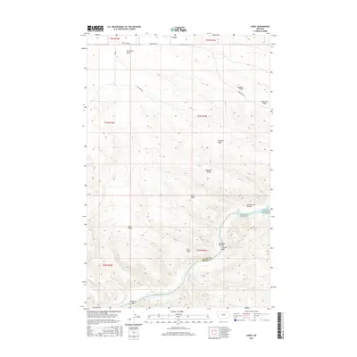
2017 Map of Leroy
USGS Topo · Published 2017About this map
The Missouri River carves a deep valley through this Montana landscape, marking the southern border of Blaine County where it meets Fergus County. The topography is defined by a series of high ridges and benches, including Pendell Ridge and Barnard Ridge, which overlook the river's winding course. Navigational challenges for early river travelers are noted at Lone Pine Rapids and Castle Bluffs Rapids, while the flat floodplains of Box Elder Bottom and Greasewood Bottom offer a sharp contrast to the surrounding high ground.
Find a feature on this map
27 named features on this map. Tap any name to fly to it.
Don’t see what you’re looking for? This feature index may not catch every label — zoom into the map to look around manually.
Map Details
Editions of this 2017 Leroy Map
This is the sole edition of this map. No revisions or reprints were ever made.
Other maps of this area

1954 · Taffy Ridge
USGS Topo · 1:24,000

1954 · Bird Rapids
USGS Topo · 1:24,000

1954 · Leroy
USGS Topo · 1:24,000

1954 · Gallatin Rapids
USGS Topo · 1:24,000

1954 · Lewistown
USGS Topo · 1:250,000

1959 · Lewistown
USGS Topo · 1:250,000

1964 · Ragland Bench
USGS Topo · 1:24,000
1985 · Nolan Reservoir
USGS Topo · 1:24,000

1985 · Woodhawk Hill
USGS Topo · 1:24,000
1985 · Sandpiper Reservoir
USGS Topo · 1:24,000