1973 Map of Leslie
USGS Topo · Published 1975About this map
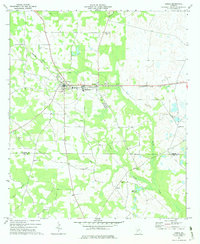
The agricultural landscape of Leslie and De Soto is defined by a dense network of country churches and rural schools that anchor this community in the 1970s. The Seaboard Coast Line railroad runs east-to-west through the center of both towns, illustrating the rail-oriented development of the region. Educational hubs like Union High Sch and Southeast Sch serve the surrounding area, while numerous spiritual landmarks such as Davis Grove Ch, Shiloh Ch, and Marthanna Grove Ch are scattered across the terrain.
Find a feature on this map
23 named features on this map. Tap any name to fly to it.
Don’t see what you’re looking for? This feature index may not catch every label — zoom into the map to look around manually.
Map Details
Editions of this 1973 Leslie Map
This is the sole edition of this map. No revisions or reprints were ever made.
Other maps of this area

1953 · Dothan
USGS Topo · 1:250,000

1953 · Waycross
USGS Topo · 1:250,000

1954 · Dothan
USGS Topo · 1:250,000

1955 · Dothan
USGS Topo · 1:250,000

1955 · Phenix City
USGS Topo · 1:250,000
1956 · Leslie
USGS Topo · 1:62,500

1957 · Phenix City
USGS Topo · 1:250,000

1957 · Macon
USGS Topo · 1:250,000

1958 · Macon
USGS Topo · 1:250,000

1958 · Phenix City
USGS Topo · 1:250,000