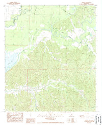
1988 Map of Lessley
USGS Topo · Published 1989About this map
The Homochitto River and its West Fk Homochitto River dominate the northern drainage of this Wilkinson County landscape during the late 1980s. The terrain transitions from the alluvial bottomlands of Alligator Bayou and Dixons Bayou to a densely dissected upland of ridges and hollows further south. The small settlement of Lessley sits centrally amidst this complex hydrology, where numerous named drainages like Peggy Row Branch and Bullet Branch feed into larger systems. The southwestern portion is defined by the course of the Buffalo River and the proximity of Foster Lake, illustrating a transition between riverine floodplains and the interior hills. This map provides a detailed view of the local drainage patterns and rural road networks just before the turn of the millennium.
Find a feature on this map
21 named features on this map. Tap any name to fly to it.
Don’t see what you’re looking for? This feature index may not catch every label — zoom into the map to look around manually.
Map Details
Editions of this 1988 Lessley Map
This is the sole edition of this map. No revisions or reprints were ever made.
Other maps of this area

1936 · Woodville
USGS Topo · 1:62,500

1939 · Kingston
USGS Topo · 1:62,500

1939 · Artonish
USGS Topo · 1:62,500

1939 · Deer Park
USGS Topo · 1:62,500

1953 · Natchez
USGS Topo · 1:250,000

1954 · Artonish
USGS Topo · 1:62,500

1955 · Artonish
USGS Topo · 1:62,500

1956 · Natchez
USGS Topo · 1:250,000

1958 · Artonish
USGS Topo · 1:62,500

1958 · Woodville
USGS Topo · 1:62,500