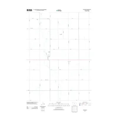
2013 Map of Lester
USGS Topo · Published 2013About this map
Lester serves as the central hub of this Lyon County agricultural landscape, situated at the intersection of Co Hwy-K30 and State Route 9. The map highlights a robust network of family-owned agricultural operations, such as Summit Farm, Crestview Farm, and Rock Bottom Dairy, which illustrate the modern farming economy of the region. Meandering through the township is Mud Cr, the primary drainage system that dictates the placement of roads and farmsteads. The grid of county roads, including Eagle Ave and Dogwood Ave, structures the terrain into precise sections typical of the tallgrass prairie region. Further south, the Meyer Stock Farm and Mogler Stock Farm emphasize the area's continued reliance on livestock production, providing researchers with specific data points for local family history and land use in the early twenty-first century.
Find a feature on this map
29 named features on this map. Tap any name to fly to it.
Don’t see what you’re looking for? This feature index may not catch every label — zoom into the map to look around manually.
Map Details
Editions of this 2013 Lester Map
This is the sole edition of this map. No revisions or reprints were ever made.
Other maps of this area

1955 · Sioux Falls
USGS Topo · 1:250,000

1958 · Sioux Falls
USGS Topo · 1:250,000

1967 · Valley Springs
USGS Topo · 1:24,000

1967 · Hills
USGS Topo · 1:24,000

1967 · Ash Creek
USGS Topo · 1:24,000

1971 · Lester
USGS Topo · 1:24,000
1971 · Inwood
USGS Topo · 1:24,000
1971 · Larchwood
USGS Topo · 1:24,000

1971 · Rock Rapids
USGS Topo · 1:24,000

1971 · Doon
USGS Topo · 1:24,000