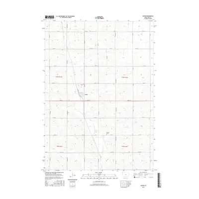
2015 Map of Lester
USGS Topo · Published 2015About this map
Lester serves as the central hub of this northwest Iowa landscape, situated where Clinton St and Hastings St meet near the banks of Mud Cr. The town is surrounded by a methodical grid of gravel and paved roads that define the agricultural character of Lyon County. Local heritage is anchored by sites like Hillside Cem just north of the village and the Apostolic Christian Cem further south along 170th St. Significant transport corridors like Iowa 9 St and various county highways, including Co Hwy A16 and Co Hwy K30, link this farming community to the broader region. The map reveals a land divided into precise townships, including t100n r47w and t99n r46w, reflecting the enduring influence of the Public Land Survey System on the Iowa prairie.
Find a feature on this map
35 named features on this map. Tap any name to fly to it.
Don’t see what you’re looking for? This feature index may not catch every label — zoom into the map to look around manually.
Map Details
Editions of this 2015 Lester Map
This is the sole edition of this map. No revisions or reprints were ever made.
Other maps of this area

1955 · Sioux Falls
USGS Topo · 1:250,000

1958 · Sioux Falls
USGS Topo · 1:250,000

1967 · Valley Springs
USGS Topo · 1:24,000

1967 · Hills
USGS Topo · 1:24,000

1967 · Ash Creek
USGS Topo · 1:24,000

1971 · Lester
USGS Topo · 1:24,000
1971 · Inwood
USGS Topo · 1:24,000
1971 · Larchwood
USGS Topo · 1:24,000

1971 · Rock Rapids
USGS Topo · 1:24,000

1971 · Doon
USGS Topo · 1:24,000