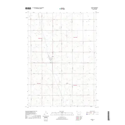
2018 Map of Lester
USGS Topo · Published 2018About this map
The town of Lester serves as the focal point for this Northwest Iowa agricultural landscape, situated at the junction of local thoroughfares like Hastings St and 5th St. The surrounding terrain is defined by the winding course of Mud Cr, which meanders through a grid-based section system of Lyon County. This 2018 survey reveals a rural infrastructure deeply tied to its cemeteries, including Hillside Cem located just north of the town center and the Apostolic Christian Cem further south. The map documents a highly structured road network, from state routes like Iowa 9 St to essential county connectors such as Co Hwy A16 and Co Hwy A20. This alignment reflects the enduring legacy of the Public Land Survey System, where north-south avenues like Eagle Ave and Elmwood Ave divide the fertile plains into precise sections.
Find a feature on this map
34 named features on this map. Tap any name to fly to it.
Don’t see what you’re looking for? This feature index may not catch every label — zoom into the map to look around manually.
Map Details
Editions of this 2018 Lester Map
This is the sole edition of this map. No revisions or reprints were ever made.
Other maps of this area

1955 · Sioux Falls
USGS Topo · 1:250,000

1958 · Sioux Falls
USGS Topo · 1:250,000

1967 · Valley Springs
USGS Topo · 1:24,000

1967 · Hills
USGS Topo · 1:24,000

1967 · Ash Creek
USGS Topo · 1:24,000

1971 · Lester
USGS Topo · 1:24,000
1971 · Inwood
USGS Topo · 1:24,000
1971 · Larchwood
USGS Topo · 1:24,000

1971 · Rock Rapids
USGS Topo · 1:24,000

1971 · Doon
USGS Topo · 1:24,000