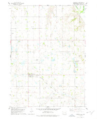
1978 Map of Lesterville
USGS Topo · Published 1979About this map
Lesterville serves as the central hub of this late-1970s South Dakota landscape, situated at the junction of the Chicago Milwaukee St Paul and Pacific railroad line. The map reveals a dense pattern of early rural settlement through its numerous burial grounds, including Odessa Cem, St Johns Cem, and Reform Cem, which are scattered throughout the surrounding townships. The eastern edge of the quadrangle is defined by the winding course of the James River, while the southern portion is drained by Beaver Creek. Human impact on the land is visible in the network of Gravel Pits and the established National Waterfowl Production Area, reflecting a balance between industrial extraction and conservation efforts in Yankton County. Genealogists will find the location of family-named landmarks such as Mueller Cem and Klasi Cem particularly valuable for tracing local heritage.
Find a feature on this map
17 named features on this map. Tap any name to fly to it.
Don’t see what you’re looking for? This feature index may not catch every label — zoom into the map to look around manually.
Map Details
Editions of this 1978 Lesterville Map
This is the sole edition of this map. No revisions or reprints were ever made.
Other maps of this area

1898 · Olivet
USGS Topo · 1:125,000

1898 · Parker
USGS Topo · 1:125,000

1955 · Sioux City
USGS Topo · 1:250,000

1955 · Sioux Falls
USGS Topo · 1:250,000

1957 · Midway
USGS Topo · 1:24,000

1957 · Menno
USGS Topo · 1:24,000

1957 · Jamesville
USGS Topo · 1:24,000

1957 · Scotland
USGS Topo · 1:24,000

1958 · Sioux City
USGS Topo · 1:250,000

1958 · Sioux Falls
USGS Topo · 1:250,000
Featured Places
- Lesterville, SD
- Odessa Township, SD
- Jamesville Township, SD
- Central Township, SD
- Lesterville Township, SD