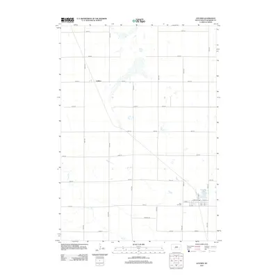
2012 Map of Letcher
USGS Topo · Published 2012About this map
The town of Letcher and its surrounding agricultural grid anchor this 2012 study of Sanborn County. The landscape is defined by the ephemeral water systems of Dry Run and Long Lake, which contrast with the structured township road network. In the village itself, the influence of the rail corridor is preserved in the naming of Railway St, while W Main St and E Main St form the local commercial core. To the west of the residential center lies West Lawn Cem, a significant site for genealogical research. Further north along the grid, the locality of Cuthbert marks a secondary point of interest in this prairie expanse, where the intersection of 236th St and 399th Ave defines the rural navigation of the era.
Find a feature on this map
27 named features on this map. Tap any name to fly to it.
Don’t see what you’re looking for? This feature index may not catch every label — zoom into the map to look around manually.
Map Details
Editions of this 2012 Letcher Map
This is the sole edition of this map. No revisions or reprints were ever made.
Other maps of this area

1898 · Huron
USGS Topo · 1:125,000

1899 · Mitchell
USGS Topo · 1:125,000

1953 · Huron
USGS Topo · 1:250,000

1954 · Huron
USGS Topo · 1:250,000

1955 · Mitchell
USGS Topo · 1:250,000

1957 · Loomis
USGS Topo · 1:24,000
1957 · Forestburg
USGS Topo · 1:24,000

1957 · Letcher NE
USGS Topo · 1:24,000

1959 · Mitchell
USGS Topo · 1:250,000
1973 · Forestburg SW
USGS Topo · 1:24,000