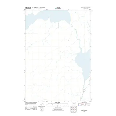
2012 Map of Lewis Falls
USGS Topo · Published 2012About this map
Shoshone Lake and Lewis Lake anchor this high-elevation landscape in Teton County, documenting the hydrology and road systems as they existed in the early twenty-first century. The map centers on the drainage patterns of Moose Cr and the Lewis River, which connects the two large water bodies before passing Lewis Falls. The southeastern corner of the sheet shows a critical transportation corridor where Highway 89 191 and 287 follow the river valley, providing a detailed record of the access routes through this wilderness area. Tributaries such as Summit Cr, Aster Cr, and Polecat Cr branch into the surrounding terrain, illustrating the intricate watershed that defines this portion of the northern Rockies. This survey captures a specific moment in the management of these federal lands, recording the precise placement of established roadways relative to the ancient watercourses of the Teton region.
Find a feature on this map
10 named features on this map. Tap any name to fly to it.
Don’t see what you’re looking for? This feature index may not catch every label — zoom into the map to look around manually.
Map Details
Editions of this 2012 Lewis Falls Map
This is the sole edition of this map. No revisions or reprints were ever made.
Other maps of this area

1886 · Shoshone
USGS Topo · 1:125,000

1888 · Shoshone
USGS Topo · 1:125,000

1895 · Shoshone
USGS Topo · 1:125,000

1901 · Shoshone
USGS Topo · 1:125,000

1908 · Shoshone
USGS Topo · 1:125,000

1911 · Shoshone
USGS Topo · 1:125,000

1955 · Ashton
USGS Topo · 1:250,000
1956 · West Thumb
USGS Topo · 1:62,500

1956 · Old Faithful
USGS Topo · 1:62,500

1956 · Grassy Lake Reservoir
USGS Topo · 1:62,500