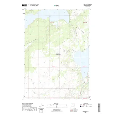
2017 Map of Lewis Falls
USGS Topo · Published 2017About this map
Yellowstone National Park terrain defines this section of Teton County, where the southern reaches of Shoshone Lake and the northern waters of Lewis Lake are connected by the Lewis River. The landscape is dominated by high-altitude features like the Cement Hills and the Red Mountains, which overlook a network of backcountry paths. The Continental Divide National Scenic Trail winds through the western portion of the map, intersecting with drainage systems like Moose Cr and Polecat Cr. Modern accessibility is centered on the South Entrance Road along the eastern edge, providing a route to the landmark Lewis Falls. This 2017 survey details the complex hydrography of the region, including the Lewis River Channel Trail and the N Shore Shoshone Lake Trail, illustrating how the protected wilderness area is navigated via established trails and historic river passages.
Find a feature on this map
23 named features on this map. Tap any name to fly to it.
Don’t see what you’re looking for? This feature index may not catch every label — zoom into the map to look around manually.
Map Details
Editions of this 2017 Lewis Falls Map
This is the sole edition of this map. No revisions or reprints were ever made.
Other maps of this area

1886 · Shoshone
USGS Topo · 1:125,000

1888 · Shoshone
USGS Topo · 1:125,000

1895 · Shoshone
USGS Topo · 1:125,000

1901 · Shoshone
USGS Topo · 1:125,000

1908 · Shoshone
USGS Topo · 1:125,000

1911 · Shoshone
USGS Topo · 1:125,000

1955 · Ashton
USGS Topo · 1:250,000
1956 · West Thumb
USGS Topo · 1:62,500

1956 · Old Faithful
USGS Topo · 1:62,500

1956 · Grassy Lake Reservoir
USGS Topo · 1:62,500