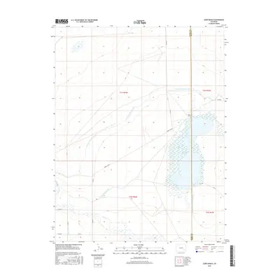
2016 Map of Lewis Ranch
USGS Topo · Published 2016About this map
Horse Cr Reservoir dominates this high-plains landscape in southeastern Colorado, straddling the county line between Otero and Bent counties. This 2016 survey highlights the intricate irrigation network essential to local agriculture, featuring the Fort Lyon Storage Canal and the Horse Cr Supply Canal which feed into the primary basin. The map documents the Horse Cr Reservoir Outlet Ditch as it moves water southward, along with smaller irrigation features like the Lewis Lateral. Settlement is sparse, anchored by the namesake Lewis Ranch located near the reservoir's northern shore. A grid of rural roads, including Timber Lake Rd and various county routes like Co RD 36, provides access across the townships of Township 21 South and Township 22 South.
Find a feature on this map
21 named features on this map. Tap any name to fly to it.
Don’t see what you’re looking for? This feature index may not catch every label — zoom into the map to look around manually.
Map Details
Editions of this 2016 Lewis Ranch Map
This is the sole edition of this map. No revisions or reprints were ever made.
Other maps of this area

1891 · Catlin
USGS Topo · 1:125,000

1891 · Las Animas
USGS Topo · 1:125,000

1893 · Las Animas
USGS Topo · 1:125,000

1893 · Catlin
USGS Topo · 1:125,000

1953 · Cheraw
USGS Topo · 1:24,000

1953 · Cornelia
USGS Topo · 1:24,000

1953 · Hadley
USGS Topo · 1:24,000

1954 · Meredith Hill
USGS Topo · 1:24,000

1954 · Lamar
USGS Topo · 1:250,000

1955 · Mc Intosh Ranch
USGS Topo · 1:24,000