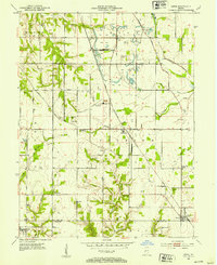
1952 Map of Lewis
USGS Topo · Published 1953About this map
Extensive surface mining operations dominate the landscape between Blackhawk and Lewis in this early 1950s survey of the Vigo and Sullivan County border. Numerous areas marked as Strip Mine and an active Oil Field illustrate the region's industrial character, contrasting with the many rural institutions that served its residents. Local family histories are preserved through numerous small burial grounds, including the Armstrong Cem, Donham Cem, and Ruggles Cem, often located near crossroads or country churches like Fletcher Chapel and Mt Olive Ch. The drainage patterns of Busserton Creek and Sponge Creek are interrupted by man-made features like Lee Lake and Hickory Grove Pond, while the Chicago Milwaukee St Paul and Pacific railroad provided the vital transport link for the area's coal and agricultural production.
Find a feature on this map
42 named features on this map. Tap any name to fly to it.
Don’t see what you’re looking for? This feature index may not catch every label — zoom into the map to look around manually.
Map Details
Editions of this 1952 Lewis Map
2 editions found
Other maps of this area

1908 · Clay City
USGS Topo · 1:48,000

1910 · Clay City
USGS Topo · 1:62,500

1940 · Lewis
USGS Topo · 1:24,000

1940 · Jasonville
USGS Topo · 1:24,000

1940 · Pimento
USGS Topo · 1:24,000

1941 · Seelyville
USGS Topo · 1:24,000

1941 · Terre Haute
USGS Topo · 1:24,000

1942 · Shelburn
USGS Topo · 1:24,000

1943 · Hymera
USGS Topo · 1:24,000

1948 · Terre Haute
USGS Topo · 1:24,000