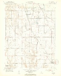
1952 Map of Lewis
USGS Topo · Published 1953About this map
The industrial and agricultural landscape of southern Vigo County is defined by extensive surface mining operations and a network of rural settlements during the early 1950s. Numerous Strip Mines and the Blackhawk Mine (Inactive) dominate the northern terrain, interspersed with local water bodies like Lee Lake and Hickory Grove Pond. This period shows a community deeply tied to the land's resources, yet still maintaining traditional roots through local gathering places such as Union Ch, Fletcher Chapel, and Mt Olive Ch.
Find a feature on this map
45 named features on this map. Tap any name to fly to it.
Don’t see what you’re looking for? This feature index may not catch every label — zoom into the map to look around manually.
Map Details
Editions of this 1952 Lewis Map
2 editions found
Other maps of this area

1908 · Clay City
USGS Topo · 1:48,000

1910 · Clay City
USGS Topo · 1:62,500

1940 · Lewis
USGS Topo · 1:24,000

1940 · Jasonville
USGS Topo · 1:24,000

1940 · Pimento
USGS Topo · 1:24,000

1941 · Seelyville
USGS Topo · 1:24,000

1941 · Terre Haute
USGS Topo · 1:24,000

1942 · Shelburn
USGS Topo · 1:24,000

1943 · Hymera
USGS Topo · 1:24,000

1948 · Terre Haute
USGS Topo · 1:24,000