
1984 Map of Lewisburg
USGS Topo · Published 1985About this map
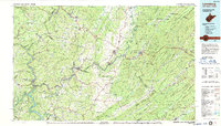
The Greenbrier River carves a winding path through this West Virginia and Virginia borderland, serving as a central artery for the valley's development and transport. By the mid-1980s, the region's landscape is defined by a mix of historic resort culture at White Sulphur Springs and significant institutional sites, including the Federal Reformatory for Women and the State Prison for Women. The map illustrates the convergence of major transportation routes like Interstate 64 and the Chesapeake and Ohio railroad, which parallel the river's course to support the timber and agricultural economy of Greenbrier County and Monroe County. From the residential streets of Lewisburg and Ronceverte to the small community of Sam Black Church, the settlement patterns reflect a reliance on the narrow fertile corridors between Peters Mountain and Brushy Ridge. Conservation areas like the Monongahela National Forest and Pipestem State Park frame the developed valleys, protecting the high ridges and the waters of Bluestone Lake.
Find a feature on this map
71 named features on this map. Tap any name to fly to it.
Don’t see what you’re looking for? This feature index may not catch every label — zoom into the map to look around manually.
Map Details
Editions of this 1984 Lewisburg Map
2 editions found
Other maps of this area

1887 · Pocahontas
USGS Topo · 1:125,000

1887 · Hinton
USGS Topo · 1:125,000

1887 · Lewisburg
USGS Topo · 1:125,000

1889 · Nicholas
USGS Topo · 1:125,000

1890 · Roanoke
USGS Topo · 1:125,000

1890 · Dublin
USGS Topo · 1:125,000

1890 · Christiansburg
USGS Topo · 1:125,000

1891 · Roanoke
USGS Topo · 1:125,000

1891 · Lewisburg
USGS Topo · 1:125,000

1891 · Nicholas
USGS Topo · 1:125,000