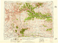
1959 Map of Lewistown
USGS Topo · Published 1959About this map
Lewistown serves as the central hub for this mid-century survey of central Montana, where the prairie transitions into the prominent peaks of the Snowy Mountains and the Judith Mountains. The map documents a sophisticated transport and industrial network, including the Great Northern and the Chicago Milwaukee St Paul and Pacific railroads, alongside a dismantled railroad line. To the east, the Cat Creek Oil Field and the Winnett Irrigation Ditch illustrate the region's reliance on natural resource extraction and water management.
Find a feature on this map
103 named features on this map. Tap any name to fly to it.
Don’t see what you’re looking for? This feature index may not catch every label — zoom into the map to look around manually.
Map Details
Editions of this 1959 Lewistown Map
3 editions found

Other maps of this area

1886 · Little Belt Mts.
USGS Topo · 1:250,000

1889 · Big Snowy Mountain
USGS Topo · 1:250,000

1890 · Fort Benton
USGS Topo · 1:250,000

1892 · Fort Benton
USGS Topo · 1:250,000

1893 · Big Snowy Mountain
USGS Topo · 1:250,000

1894 · Little Belt Mts.
USGS Topo · 1:250,000

1897 · Fort Benton
USGS Topo · 1:250,000

1897 · Little Belt Mts.
USGS Topo · 1:250,000

1898 · Little Belt Mts.
USGS Topo · 1:250,000

1902 · Little Belt Mts.
USGS Topo · 1:250,000