1986 Map of Lexington
USGS Topo · Published 1986About this map
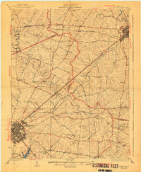
The Kentucky River carves a deep path through the Bluegrass region, framing the capital city of Frankfort and the expanding urban core of Lexington. This mid-1980s landscape reveals the heavy influence of institutional and military footprints, from the Lexington Blue Grass Army Depot to educational and correctional facilities like Kentucky State University and the Blackburn Correctional Institute. Transport networks show a high-density system of transit with the Seaboard System Railroad and Southern Railway intersecting major thoroughfares like the Blue Grass Parkway.
Find a feature on this map
292 named features on this map. Tap any name to fly to it.
Don’t see what you’re looking for? This feature index may not catch every label — zoom into the map to look around manually.
Map Details
Editions of this 1986 Lexington Map
This is the sole edition of this map. No revisions or reprints were ever made.
Historical Maps of Lexington Through Time
3 maps found