1919 Map of Maysville
USGS Topo · Published 1936About this map
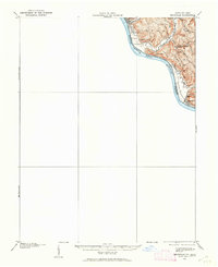
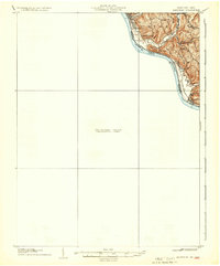
Ripley and the surrounding river bluffs along the northern bank of the Ohio River dominate the surveyed portion of this early twentieth-century sheet. The landscape is defined by its ridge-and-valley settlement pattern, where narrow roads like Blooming Ridge Road and Union Road follow the high ground to connect small rural communities. These uplands were once centers of local education, evidenced by the high density of neighborhood institutions including Buckeye School, Hawk School, Fitch School, and Flaugher School. Below these heights, the land drops sharply into carved drainages like Ghost Hollow and Eagle Creek, with the prominent Charleston Bar showing in the river channel near Hestoria. While the southern portion across the Brown Co and Mason Co border remains a Preliminary Edition Unsurveyed Area, the detailed topography of the northern shore captures the transition from the riverfront at Aberdeen to the heights of Cedar Hill.
Find a feature on this map
29 named features on this map. Tap any name to fly to it.
Don’t see what you’re looking for? This feature index may not catch every label — zoom into the map to look around manually.
Map Details
Editions of this 1919 Maysville Map
This is the sole edition of this map. No revisions or reprints were ever made.
Historical Maps of Maysville Through Time
4 maps found