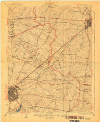
1986 Map of Lexington
USGS Topo · Published 1986This historical map portrays the area of Lexington in 1986, primarily covering Fayette County as well as portions of Shelby County, Robertson County, Henry County, Clark County, Owen County, Montgomery County, Woodford County, Grant County, Nicholas County, Anderson County, Bourbon County, Harrison County, Scott County, Jessamine County, and Franklin County. Featuring a scale of 1:100000, this map provides a highly detailed snapshot of the terrain, roads, buildings, counties, and historical landmarks in the Lexington region at the time. Published in 1986, it is the sole known edition of this map.
Find a feature on this map
292 named features on this map. Tap any name to fly to it.
Don’t see what you’re looking for? This feature index may not catch every label — zoom into the map to look around manually.
Map Details
Editions of this 1986 Lexington Map
This is the sole edition of this map. No revisions or reprints were ever made.
Historical Maps of New Zion Through Time
3 maps found