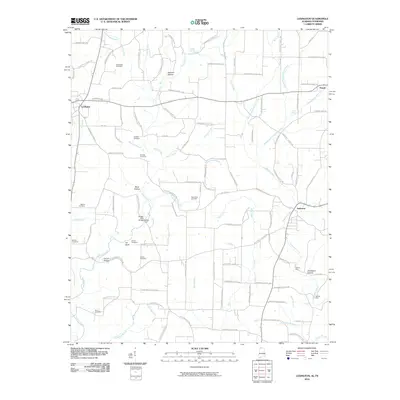
2010 Map of Lexington
USGS Topo · Published 2010About this map
Lexington and Anderson anchor this Lauderdale County landscape where the Tennessee-Alabama border country is defined by a dense network of creek valleys and family-named hollows. The terrain is marked by numerous watercrossings, including Sledge Ford Bridge and the namesake Sledge Ford on Second Creek, alongside Ingram Ford and Moody Ford further east. For genealogists, the map is particularly rich in family burial sites, documenting locations for the Portertown Cemetery, Shelton Cemetery, Harmon Cemetery, and Brown Cemetery among others. Several geographic landmarks such as Ivy Bluff, Sawmill Hollow, and Corum Hollow illustrate how the local topography influenced early settlement patterns. Small communities like Powell appear along the northern reaches, connected by a web of local routes including the Betty Hwy, which traverses the central ridges between Anderson Creek and First Creek.
Find a feature on this map
115 named features on this map. Tap any name to fly to it.
Don’t see what you’re looking for? This feature index may not catch every label — zoom into the map to look around manually.
Map Details
Editions of this 2010 Lexington Map
This is the sole edition of this map. No revisions or reprints were ever made.
Other maps of this area

1914 · Rogersville
USGS Topo · 1:48,000

1916 · Rogersville
USGS Topo · 1:62,500

1936 · Union Hill
USGS Topo · 1:24,000

1936 · Thorntontown
USGS Topo · 1:24,000

1936 · Lexington
USGS Topo · 1:24,000

1936 · Loretto
USGS Topo · 1:24,000

1936 · Wheeler Dam
USGS Topo · 1:24,000
1936 · Center Hill
USGS Topo · 1:24,000

1936 · Appleton
USGS Topo · 1:24,000

1936 · Cairo
USGS Topo · 1:24,000