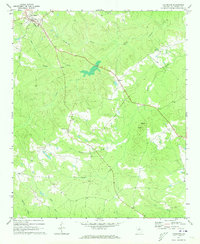
1971 Map of Lexington
USGS Topo · Published 1973About this map
Lexington serves as the primary hub of this Oglethorpe County landscape, where small crossroads and rural landmarks define the community structure during the early 1970s. The topography is intricately carved by a dense network of waterways, including Troublesome Creek, Buffalo Creek, and Milner Brook, which dictate the placement of early settlements and road crossings. For genealogists and local historians, the sheet is particularly valuable for its documentation of rural congregations and burial grounds, such as Salem Ch, Clark Grove Ch, Pentecost Ch, and the Wynne Cem. Notable landmarks like the Lookout Tower on Big Mtn and the small settlement of Hogan provide specific points of reference for tracing family homesteads and local land use. This survey reflects a traditional Georgia Piedmont landscape where agricultural clearings and forested ridges remained the dominant features before significant modern development.
Find a feature on this map
22 named features on this map. Tap any name to fly to it.
Don’t see what you’re looking for? This feature index may not catch every label — zoom into the map to look around manually.
Map Details
Editions of this 1971 Lexington Map
2 editions found

Other maps of this area

1906 · Crawfordville
USGS Topo · 1:125,000

1953 · Athens
USGS Topo · 1:250,000

1958 · Athens
USGS Topo · 1:250,000

1959 · Athens
USGS Topo · 1:250,000

1963 · Athens
USGS Topo · 1:250,000

1965 · Woodville
USGS Topo · 1:24,000

1966 · Philomath
USGS Topo · 1:24,000
1971 · Sandy Cross
USGS Topo · 1:24,000
1971 · Crawford
USGS Topo · 1:24,000

1971 · Maxeys
USGS Topo · 1:24,000