
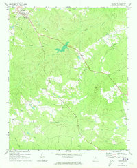
1971 Map of Lexington
USGS Topo · Published 1991About this map
Lexington serves as the focal point of this Oglethorpe County landscape, positioned near the headwaters of Town Creek. The topography is defined by a dense network of tributaries including Troublesome Creek, Brooks Creek, and Long Creek, which carve through the Piedmont terrain toward the Buffalo Creek drainage. The map reveals a rural social geography centered around crossroads and rural congregations, such as Salem Ch, Clark Grove Ch, and Pentecost Ch. To the south, Big Mtn rises as a prominent high point, capped by a Lookout Tower. Genealogists will find several burial sites noted across the countryside, ranging from the established Wesley Chapel Cem and Wynne Cem to isolated family plots marked simply as Grave. The layout of local roads and the small settlement at Hogan reflect the post-war agricultural and residential patterns of this Georgia county.
Find a feature on this map
23 named features on this map. Tap any name to fly to it.
Don’t see what you’re looking for? This feature index may not catch every label — zoom into the map to look around manually.
Map Details
Editions of this 1971 Lexington Map
2 editions found
Other maps of this area

1906 · Crawfordville
USGS Topo · 1:125,000

1953 · Athens
USGS Topo · 1:250,000

1958 · Athens
USGS Topo · 1:250,000

1959 · Athens
USGS Topo · 1:250,000

1963 · Athens
USGS Topo · 1:250,000

1965 · Woodville
USGS Topo · 1:24,000

1966 · Philomath
USGS Topo · 1:24,000
1971 · Sandy Cross
USGS Topo · 1:24,000
1971 · Crawford
USGS Topo · 1:24,000

1971 · Maxeys
USGS Topo · 1:24,000