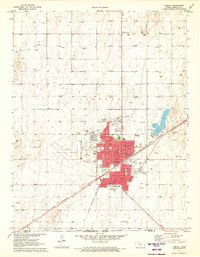
1971 Map of Liberal
USGS Topo · Published 1973About this map
Liberal sits at the intersection of industry and civic growth along the Chicago Rock Island and Pacific railroad during the early 1970s. The town's grid is dense with educational and community landmarks, ranging from the central Courthouse and City Hall to a high concentration of neighborhood schools like Garfield Sch and Southlawn Sch. To the west, the Liberal Municipal Airport and Fairground mark the expansion of the city limits, while the surrounding landscape is punctuated by a high density of gas and oil wells, reflecting the energy economy of Seward County. The map captures the transition from the structured urban core of Westhaven to the wide plains of the Kansas-Oklahoma border. Cultural markers of the era are visible throughout, including the local Drive-in Theater and the Southwest Medical Center, providing a detailed look at the infrastructure serving this High Plains hub.
Find a feature on this map
33 named features on this map. Tap any name to fly to it.
Don’t see what you’re looking for? This feature index may not catch every label — zoom into the map to look around manually.
Map Details
Editions of this 1971 Liberal Map
3 editions found
Other maps of this area

1954 · Perryton
USGS Topo · 1:250,000

1955 · Dodge City
USGS Topo · 1:250,000

1958 · Perryton
USGS Topo · 1:250,000

1958 · Dodge City
USGS Topo · 1:250,000

1959 · Dodge City
USGS Topo · 1:250,000

1967 · Tyrone
USGS Topo · 1:24,000

1968 · Liberal NE
USGS Topo · 1:24,000

1968 · Liberal NW
USGS Topo · 1:24,000

1971 · Liberal
USGS Topo · 1:24,000

1971 · Hayne
USGS Topo · 1:24,000