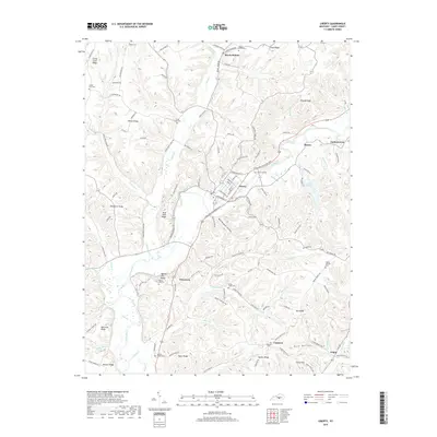
2019 Map of Liberty
USGS Topo · Published 2019About this map
Liberty serves as the central hub of this Casey County landscape, where the Green River winds through a complex system of ridges and hollows. The settlement pattern is deeply tied to the high ground, with numerous family and community landmarks such as Walnut Hill Cem and Murphy Family Cem positioned along the crests of Walnut Hill Ridge and Taylor Ridge. Local connectivity is defined by named routes like Campbellsville St and Hustonville St, which link the town to outlying areas like Pricetown and Beech Bottom. In the eastern portion of the map, Lake Liberty provides a significant water feature near Lanhamtown, while the southern reaches near Gilpin are characterized by deep drainage basins like Huff Hollow and the flow of Tarter Br. The density of small cemeteries, including Mason Creek Cem and Poplar Springs Cem, offers significant detail for genealogical research into the families who settled these Kentucky hillsides.
Find a feature on this map
127 named features on this map. Tap any name to fly to it.
Don’t see what you’re looking for? This feature index may not catch every label — zoom into the map to look around manually.
Map Details
Editions of this 2019 Liberty Map
This is the sole edition of this map. No revisions or reprints were ever made.
Other maps of this area

1952 · Ellisburg
USGS Topo · 1:24,000

1952 · Hustonville
USGS Topo · 1:24,000

1952 · Clementsville
USGS Topo · 1:24,000

1952 · Liberty
USGS Topo · 1:24,000

1952 · Yosemite
USGS Topo · 1:24,000

1953 · Bradfordsville NE
USGS Topo · 1:24,000

1953 · Phil
USGS Topo · 1:24,000

1953 · Mintonville
USGS Topo · 1:24,000

1953 · Dunnville
USGS Topo · 1:24,000

1957 · Winchester
USGS Topo · 1:250,000