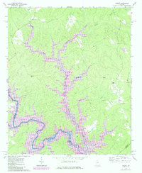
1972 Map of Liberty
USGS Topo · Published 1984About this map
Lake Oconee dominates the lower portion of this map, its winding fingers extending into the drainages of Richland Creek and Sandy Creek. The landscape represents a mid-century transition where the newly formed reservoir met the long-established rural communities of Greene and Putnam Counties. In the eastern uplands, the settlement of Liberty remains a focal point, supported by local landmarks like Liberty Chapel and the nearby Lawrence Center Ch. The topography is defined by numerous watercourses, including Beaverdam Creek and Stewarts Creek, which carve through the wooded terrain. Historical remnants of earlier generations are visible in the form of isolated burial sites and rural houses of worship, such as Old Salem Cem, Mt Calvary Ch, and Flat Rock Ch, offering a look at the community fabric before large-scale recreational development began to reshape the area around the Oconee River.
Find a feature on this map
25 named features on this map. Tap any name to fly to it.
Don’t see what you’re looking for? This feature index may not catch every label — zoom into the map to look around manually.
Map Details
Editions of this 1972 Liberty Map
2 editions found
Other maps of this area

1953 · Athens
USGS Topo · 1:250,000

1958 · Athens
USGS Topo · 1:250,000

1959 · Athens
USGS Topo · 1:250,000

1963 · Athens
USGS Topo · 1:250,000

1965 · Union Point
USGS Topo · 1:24,000

1972 · Liberty
USGS Topo · 1:24,000

1972 · Shoulderbone
USGS Topo · 1:24,000

1972 · Meda
USGS Topo · 1:24,000

1972 · Buckhead
USGS Topo · 1:24,000

1972 · Harmony
USGS Topo · 1:24,000