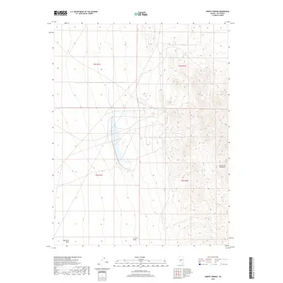
2018 Map of Liberty Springs
USGS Topo · Published 2018About this map
San Antonio Mountains rise sharply in the eastern portion of this map, overlooking the arid expanse of the Big Smoky Valley to the west. This high-desert landscape in Nye County, Nevada, is punctuated by Liberty Springs, a vital water source situated on the mountain slopes. To the south, the Crescent Dunes present a distinct geological formation at the valley's edge. The 2018 survey reveals a terrain defined by dramatic elevation changes, where the steep contours of the mountains contrast with the broad, open flats of the valley floor. The map highlights the intersection of several townships, including t6n r41e, t6n r42e, t5n r41e, and t5n r42e, illustrating the systematic division of this remote public land. The lack of significant road infrastructure or settlements underscores the isolated nature of this desert environment.
Find a feature on this map
8 named features on this map. Tap any name to fly to it.
Don’t see what you’re looking for? This feature index may not catch every label — zoom into the map to look around manually.
Map Details
Editions of this 2018 Liberty Springs Map
This is the sole edition of this map. No revisions or reprints were ever made.
Other maps of this area

1907 · Tonopah
USGS Topo · 1:250,000

1908 · Tonopah
USGS Topo · 1:250,000

1956 · Tonopah
USGS Topo · 1:250,000

1959 · Tonopah
USGS Topo · 1:250,000

1961 · Tonopah
USGS Topo · 1:62,500

1961 · Lone Mtn
USGS Topo · 1:62,500

1962 · Tonopah
USGS Topo · 1:250,000

1963 · Baxter Spring
USGS Topo · 1:62,500

1964 · San Antonio Ranch
USGS Topo · 1:62,500
1987 · Rays
USGS Topo · 1:24,000