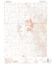
1987 Map of Liberty Springs
USGS Topo · Published 1987About this map
The San Antonio Mountains rise sharply above the desert floor on this 1987 provisional survey, revealing a landscape defined by heavy industry and arid topography. The Liberty Mine dominates the central eastern portion of the sheet, surrounded by an extensive Open Pit Mine and massive Mine Dump sites. This industrial footprint is supported by a network of infrastructure including an Aqueduct, several Transmission Lines, and a Tailings Pond that captures runoff from the extraction sites.
Find a feature on this map
16 named features on this map. Tap any name to fly to it.
Don’t see what you’re looking for? This feature index may not catch every label — zoom into the map to look around manually.
Map Details
Editions of this 1987 Liberty Springs Map
This is the sole edition of this map. No revisions or reprints were ever made.
Other maps of this area

1907 · Tonopah
USGS Topo · 1:250,000

1908 · Tonopah
USGS Topo · 1:250,000

1956 · Tonopah
USGS Topo · 1:250,000

1959 · Tonopah
USGS Topo · 1:250,000

1961 · Tonopah
USGS Topo · 1:62,500

1961 · Lone Mtn
USGS Topo · 1:62,500

1962 · Tonopah
USGS Topo · 1:250,000

1963 · Baxter Spring
USGS Topo · 1:62,500

1964 · San Antonio Ranch
USGS Topo · 1:62,500
1987 · Rays
USGS Topo · 1:24,000