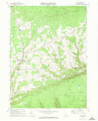
1969 Map of Liberty
USGS Topo · Published 1972About this map
Liberty and the surrounding townships of Liberty, Union, and Jackson define this mid-century look at the Tioga and Lycoming county border. The landscape is heavily shaped by the rugged elevations of Brier Mountain and Laurel Hill, which are largely preserved within the Tioga State Forest and Tiadaghton State Forest. While much of the area is dense woodland, the valleys along Blacks Creek and Roaring Branch contain clear signs of rural life and small-scale industry, including the Strip Mine in the southeast and the House Landing Strip near the main settlement.
Find a feature on this map
32 named features on this map. Tap any name to fly to it.
Don’t see what you’re looking for? This feature index may not catch every label — zoom into the map to look around manually.
Map Details
Editions of this 1969 Liberty Map
Other maps of this area

1921 · Trout Run
USGS Topo · 1:62,500

1923 · Trout Run
USGS Topo · 1:62,500

1925 · Blossburg
USGS Topo · 1:62,500

1927 · Blossburg
USGS Topo · 1:62,500

1930 · Warrensville
USGS Topo · 1:62,500

1934 · Warrensville
USGS Topo · 1:62,500

1942 · Canton
USGS Topo · 1:62,500

1944 · Blossburg
USGS Topo · 1:62,500

1944 · Trout Run
USGS Topo · 1:62,500

1944 · Canton
USGS Topo · 1:62,500
Featured Places
- Liberty, PA
- Veilstown, Liberty Township
- Union Township, PA
- House Landing Strip, Liberty Township
- Jackson Township, PA