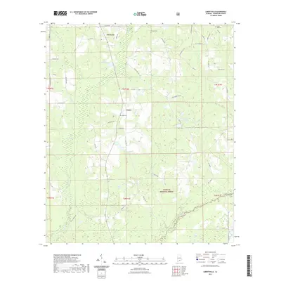
2021 Map of Libertyville
USGS Topo · Published 2021About this map
Libertyville and the nearby settlement of Stanley serve as the primary hubs in this part of Covington County, characterized by a transition from agricultural family farms to the protected timberlands of the Conecuh National Forest. The landscape is defined by a dense network of hydrologic features, including the Yellow River, Five Runs Creek, and several localized impoundments such as Little Okeechobee Pond and Maddox Ponds. Local family history is rooted in the landscape through numerous named roads like Sammy Brown Farm Rd, Catherine Bailey Rd, and Willie Moore Rd, which lead to established community landmarks like Five Runs Cem and Oakey Ridge Cem. In the southeastern quadrant, Cravey Bridge provides a crossing near the Cravey Ponds, marking a key point of navigation through the marshy lowland terrain typical of this coastal plain region.
Find a feature on this map
59 named features on this map. Tap any name to fly to it.
Don’t see what you’re looking for? This feature index may not catch every label — zoom into the map to look around manually.
Map Details
Editions of this 2021 Libertyville Map
This is the sole edition of this map. No revisions or reprints were ever made.
Other maps of this area

1953 · Andalusia
USGS Topo · 1:250,000

1957 · Andalusia
USGS Topo · 1:250,000

1971 · Carolina
USGS Topo · 1:24,000

1971 · Libertyville
USGS Topo · 1:24,000

1971 · Onycha
USGS Topo · 1:24,000

1971 · Wing
USGS Topo · 1:24,000

1971 · River Falls
USGS Topo · 1:24,000

1971 · Andalusia
USGS Topo · 1:24,000
1971 · Florala
USGS Topo · 1:24,000
1971 · Watkins Bridge
USGS Topo · 1:24,000