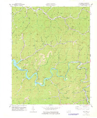
1978 Map of Lick Creek
USGS Topo · Published 1978About this map
The waters of Fishtrap Lake and the Levisa Fork dominate this 1970s landscape in Pike County, revealing a region defined by its coal-rich topography and narrow valley settlements. The map illustrates a dense industrial network where Strip Mines and numerous unnamed mines dot the ridgelines above communities like Kimper and Phyllis. Transport is centered on the Norfolk and Western railroad, which snakes alongside the river and through the Lick Creek Sta. Local history is preserved in the placement of family landmarks and small congregations, including the Flanary Cem, Elswick Ch, and Cedar Bottom Ch. The map captures the area after the completion of the Fishtrap Dam, showing the flooded contours of the Levisa Fork valley and the resulting shoreline that altered the connectivity of local hollows like Happy Hollow and Feds Hollow.
Find a feature on this map
64 named features on this map. Tap any name to fly to it.
Don’t see what you’re looking for? This feature index may not catch every label — zoom into the map to look around manually.
Map Details
Editions of this 1978 Lick Creek Map
This is the sole edition of this map. No revisions or reprints were ever made.
Other maps of this area

1886 · Grundy
USGS Topo · 1:125,000

1887 · Warfield
USGS Topo · 1:125,000

1890 · Grundy
USGS Topo · 1:125,000

1891 · Warfield
USGS Topo · 1:125,000

1892 · Grundy
USGS Topo · 1:125,000

1909 · Matewan
USGS Topo · 1:48,000

1914 · Hurley
USGS Topo · 1:48,000

1915 · Regina
USGS Topo · 1:48,000

1915 · Hurley
USGS Topo · 1:48,000

1915 · Williamson
USGS Topo · 1:48,000