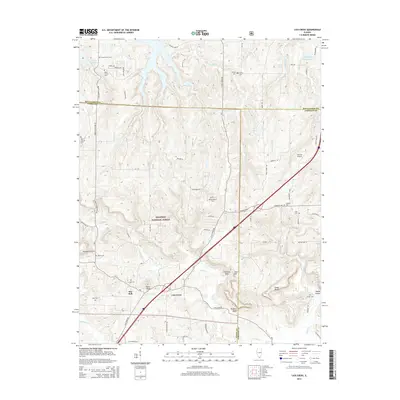
2015 Map of Lick Creek
USGS Topo · Published 2015About this map
Shawnee National Forest dominates the terrain of this Southern Illinois landscape, where the ridges and drainages of the Lick Creek watershed define the settlement patterns. The map documents a rural network of family cemeteries and small community centers, such as The Hall and the settlement of Lick Creek, reflecting a deeply rooted local history. Natural landmarks like Drapers Bluff, Cedar Bluff, and Chimney Rock stand as prominent features amidst the complex topography. To the north, the waters of Little Grassy Lake and Pleasant Valley Lake mark the transition into more water-abundant areas. This survey serves as an essential record for tracing genealogies and land ownership, showing numerous family-named landmarks including Baker Family Cem, Chitty Cem, and Gurley Cem, which anchor the area's pioneer heritage to the modern grid.
Find a feature on this map
71 named features on this map. Tap any name to fly to it.
Don’t see what you’re looking for? This feature index may not catch every label — zoom into the map to look around manually.
Map Details
Editions of this 2015 Lick Creek Map
This is the sole edition of this map. No revisions or reprints were ever made.
Other maps of this area

1918 · Vienna
USGS Topo · 1:62,500

1919 · Vienna
USGS Topo · 1:62,500

1920 · Dongola
USGS Topo · 1:62,500

1922 · Carbondale
USGS Topo · 1:62,500

1923 · Dongola
USGS Topo · 1:62,500

1925 · Marion
USGS Topo · 1:62,500

1940 · Marion
USGS Topo · 1:62,500

1941 · Carbondale
USGS Topo · 1:62,500

1942 · Vienna
USGS Topo · 1:62,500

1949 · Paducah
USGS Topo · 1:250,000