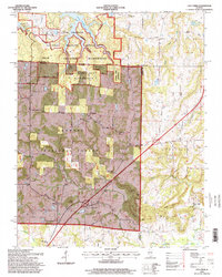
1996 Map of Lick Creek
USGS Topo · Published 1999About this map
Wayside and Lick Creek serve as the primary nodes of settlement in this southern Illinois landscape, situated at the intersection of Union, Williamson, and Johnson counties. The region is defined by significant federal and state protected lands, including the Panther Den Wilderness and portions of the Shawnee National Forest. The topography is shaped by dramatic sandstone features like Chimney Rock and Drapers Bluff, with the River to River Trail traversing the wooded hills and creek valleys. Numerous country churches and family burial grounds, such as Cumberland Ch and the Old Pleasant Hill Cem, are scattered across the terrain, reflecting a deep-rooted rural community. To the north, the waters of Devils Kitchen Lake and Little Grassy Lake provide a transition from the dense forest to the managed lands of the Crab Orchard National Wildlife Refuge.
Find a feature on this map
49 named features on this map. Tap any name to fly to it.
Don’t see what you’re looking for? This feature index may not catch every label — zoom into the map to look around manually.
Map Details
Editions of this 1996 Lick Creek Map
This is the sole edition of this map. No revisions or reprints were ever made.
Other maps of this area

1918 · Vienna
USGS Topo · 1:62,500

1919 · Vienna
USGS Topo · 1:62,500

1920 · Dongola
USGS Topo · 1:62,500

1922 · Carbondale
USGS Topo · 1:62,500

1923 · Dongola
USGS Topo · 1:62,500

1925 · Marion
USGS Topo · 1:62,500

1940 · Marion
USGS Topo · 1:62,500

1941 · Carbondale
USGS Topo · 1:62,500

1942 · Vienna
USGS Topo · 1:62,500

1949 · Paducah
USGS Topo · 1:250,000