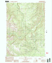
1990 Map of Lick Creek
USGS Topo · Published 1990About this map
Wallowa National Forest land defines this corner of Oregon, where the high-elevation terrain of the Imnaha Divide meets a complex network of canyons and creeks. The landscape is split by significant administrative boundaries, including the edge of the Eagle Cap Wilderness to the west and the Hells Canyon National Recreation Area to the southeast. Industrial and forest management history is evident at the Zollman and Wells Mine and the Dick Creek Guard Station, while recreation is anchored by the Lick Creek Campground. Water management is represented by the Wallowa Weir on the upper reaches of Sheep Creek, a tributary to the larger Big Sheep Creek. Steep ridges such as Wing Ridge and summits like Tyee Butte rise above deep drainages like Echo Canyon, illustrating the challenging geography of the northern Wallowa Mountains.
Find a feature on this map
30 named features on this map. Tap any name to fly to it.
Don’t see what you’re looking for? This feature index may not catch every label — zoom into the map to look around manually.
Map Details
Editions of this 1990 Lick Creek Map
2 editions found
Other maps of this area

1954 · Cornucopia
USGS Topo · 1:62,500

1954 · Harl Butte
USGS Topo · 1:62,500

1955 · Grangeville
USGS Topo · 1:250,000

1957 · Joseph
USGS Topo · 1:62,500

1957 · Homestead
USGS Topo · 1:62,500

1959 · Grangeville
USGS Topo · 1:250,000

1986 · Enterprise
USGS Topo · 1:100,000

1987 · Riggins
USGS Topo · 1:100,000
1990 · Deadman Point
USGS Topo · 1:24,000
1990 · Gumboot Butte
USGS Topo · 1:24,000