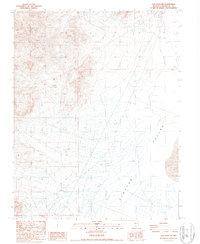
1987 Map of Lida Wash NW
USGS Topo · Published 1987About this map
Clayton Valley dominates the eastern half of this 1980s-era landscape, where the flat basin floor gives way to an environment of industrial extraction. The western terrain is defined by numerous prospects, a Borrow Pit, and a localized Tailings Pond, indicating a focus on mineral exploration and resource management. Infrastructure in this arid region is sparse but specific, including a Pumping Station, a Tank, and Two Single Pole Trans Lines that cut across the valley floor. To the southeast, an area of Sand Dunes marks a transition in the valley's surface composition, while a network of 4wd tracks provides the primary means of navigating the desert floor and its surrounding slopes.
Find a feature on this map
13 named features on this map. Tap any name to fly to it.
Don’t see what you’re looking for? This feature index may not catch every label — zoom into the map to look around manually.
Map Details
Editions of this 1987 Lida Wash NW Map
This is the sole edition of this map. No revisions or reprints were ever made.
Other maps of this area

1898 · Silver Peak
USGS Topo · 1:125,000

1900 · Silver Peak
USGS Topo · 1:125,000

1908 · Lida
USGS Topo · 1:250,000

1913 · Lida
USGS Topo · 1:250,000

1954 · Goldfield
USGS Topo · 1:250,000

1955 · Goldfield
USGS Topo · 1:250,000

1958 · Goldfield
USGS Topo · 1:250,000

1962 · Goldfield
USGS Topo · 1:250,000
1963 · Piper Peak
USGS Topo · 1:62,500

1963 · Silver Peak
USGS Topo · 1:62,500