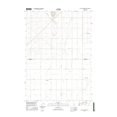
2017 Map of Lidy Hot Springs SE
USGS Topo · Published 2017About this map
Emigrant Trail Rd marks a historic passage through this high desert landscape, following a route that long preceded the modern grid of Jefferson County. The terrain is defined by the gentle drainage of Warm Springs Cr as it moves toward the lowlands, set against a backdrop of organized township and range sections. The map reveals a transition from the open ranges along Crooked Creek Rd in the north to the increasingly structured agricultural roads of the south. Local transit is anchored by the Monteview Hwy, which provides a primary north-south artery through the area. Personal and family history is etched into the landscape through named corridors such as Schwendig Rd, Attkins Rd, and McCrary Rd, which document the distribution of rural landholdings and the evolution of the local transportation network at this point in the early twenty-first century.
Find a feature on this map
21 named features on this map. Tap any name to fly to it.
Don’t see what you’re looking for? This feature index may not catch every label — zoom into the map to look around manually.
Map Details
Editions of this 2017 Lidy Hot Springs SE Map
This is the sole edition of this map. No revisions or reprints were ever made.
Other maps of this area

1955 · Dubois
USGS Topo · 1:250,000

1955 · Idaho Falls
USGS Topo · 1:250,000

1958 · Dubois
USGS Topo · 1:250,000

1958 · Idaho Falls
USGS Topo · 1:250,000

1964 · Small
USGS Topo · 1:24,000

1964 · Cedar Butte SW
USGS Topo · 1:24,000

1964 · Mud Lake NW
USGS Topo · 1:24,000

1969 · Shamrock Gulch
USGS Topo · 1:24,000

1969 · Lidy Hot Springs SE
USGS Topo · 1:24,000

1969 · Circular Butte NW
USGS Topo · 1:24,000