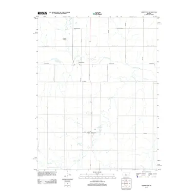
2012 Map of Liebenthal
USGS Topo · Published 2012About this map
The Smoky Hill River meanders across the northern portion of this Ellis County landscape, a vital watercourse for the agrarian communities of Schoenchen and Liebenthal. This 2012 survey illustrates the enduring grid of the High Plains, where section-line roads like Chetolah Gold Rd and Smoky Hill River Rd define the territory. The map is particularly valuable for genealogical research, documenting local parish history at Saint Anthony Cem and Saint Joseph Cem. Topographical features such as Lookout Hollow and the drainage of Big Timber Cr provide a clear view of the natural relief that breaks the horizon south of the river. The small-town infrastructure is centered on landmarks such as the local Post Office in Liebenthal, connected by a network of county highways including Co Hwy-44 and Co Hwy-507.
Find a feature on this map
24 named features on this map. Tap any name to fly to it.
Don’t see what you’re looking for? This feature index may not catch every label — zoom into the map to look around manually.
Map Details
Editions of this 2012 Liebenthal Map
This is the sole edition of this map. No revisions or reprints were ever made.
Other maps of this area

1896 · Hays
USGS Topo · 1:125,000

1955 · Great Bend
USGS Topo · 1:250,000

1957 · Great Bend
USGS Topo · 1:250,000

1958 · Great Bend
USGS Topo · 1:250,000

1961 · Hays South
USGS Topo · 1:24,000

1961 · Antonino
USGS Topo · 1:24,000

1961 · Victoria
USGS Topo · 1:24,000

1966 · La Crosse
USGS Topo · 1:24,000

1966 · Hargrave
USGS Topo · 1:24,000
1966 · Bison
USGS Topo · 1:24,000