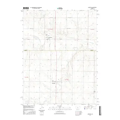
2015 Map of Liebenthal
USGS Topo · Published 2015About this map
Schoenchen and Liebenthal anchor this central Kansas landscape at the border of Ellis and Rush counties. The topography is defined by the winding course of the Smoky Hill River to the north and the drainage of Big Timber Cr to the south. Historically significant sites for genealogists include Saint Anthony Cem near the river bluffs and Saint Joseph Cem situated on the southern plains. The township-and-range grid is heavily developed with rural routes like Chetolah Gold Rd and Schoenchen Rd, reflecting a region deeply tied to agriculture and regional transport. Local landmarks such as Lookout Hollow and Hungry Hollow provide specific geographical identifiers for those researching 21st-century land use or family history in these rural communities.
Find a feature on this map
45 named features on this map. Tap any name to fly to it.
Don’t see what you’re looking for? This feature index may not catch every label — zoom into the map to look around manually.
Map Details
Editions of this 2015 Liebenthal Map
This is the sole edition of this map. No revisions or reprints were ever made.
Other maps of this area

1896 · Hays
USGS Topo · 1:125,000

1955 · Great Bend
USGS Topo · 1:250,000

1957 · Great Bend
USGS Topo · 1:250,000

1958 · Great Bend
USGS Topo · 1:250,000

1961 · Hays South
USGS Topo · 1:24,000

1961 · Antonino
USGS Topo · 1:24,000

1961 · Victoria
USGS Topo · 1:24,000

1966 · La Crosse
USGS Topo · 1:24,000

1966 · Hargrave
USGS Topo · 1:24,000
1966 · Bison
USGS Topo · 1:24,000