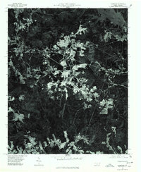
1976 Map of Lilesville
USGS Topo · Published 1978About this map
Blewett Falls Lake dominates the northeastern corner of this landscape, where the Pee Dee River flows through the border of Anson County. The terrain is defined by a dense network of forest and clearings, with the settlement of Lilesville situated in the northwestern quadrant along major transportation corridors. To the south, the smaller community of Cairo sits within a patchwork of agricultural lands and woodland. This 1976 orthophotoquad provides a clear visual record of land use and vegetation patterns during the mid-1970s, captured just before the close of the decade by the Geological Survey. The imagery reveals the intensity of local quarrying or industrial clearing near the center of the quadrangle, contrasting sharply with the surrounding timberlands and the natural flow of the Pee Dee boundary.
Find a feature on this map
5 named features on this map. Tap any name to fly to it.
Don’t see what you’re looking for? This feature index may not catch every label — zoom into the map to look around manually.
Map Details
Editions of this 1976 Lilesville Map
This is the sole edition of this map. No revisions or reprints were ever made.
Other maps of this area

1941 · Spartanburg
USGS Topo · 1:250,000

1942 · Troy
USGS Topo · 1:125,000

1942 · Rockingham
USGS Topo · 1:125,000

1953 · Florence
USGS Topo · 1:250,000

1953 · Raleigh
USGS Topo · 1:250,000

1953 · Spartanburg
USGS Topo · 1:250,000

1953 · Charlotte
USGS Topo · 1:250,000

1954 · Charlotte
USGS Topo · 1:250,000

1954 · Florence
USGS Topo · 1:250,000

1954 · Raleigh
USGS Topo · 1:250,000