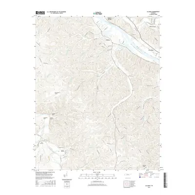
2016 Map of Lillamay
USGS Topo · Published 2016About this map
The Cumberland River and Harpeth River carve dramatic loops through the terrain of Cheatham and Davidson Counties, creating isolated peninsulas and distinctive landforms. Among the most notable is The Narrows, where the Harpeth neck narrows significantly, and the nearby Mound Bottom, an area defined by its sharp river bend. These natural features, along with Horseshoe Bend, illustrate how the drainage patterns of waterways like Sams Creek and Marrowbone Creek have sculpted this part of the Tennessee landscape. Small settlements and points of interest such as Lillamay, Gravelotte, and Sulphur Springs are connected by a network of winding roads like Old Charlotte Pike and Wiley Pardue Road. Local history is preserved in family landmarks and burial sites, including Carney Cemetery and Scott Cemetery, while hollows like Deep Springs Hollow and Gardling Hollow further define the intricate topography of the region.
Find a feature on this map
85 named features on this map. Tap any name to fly to it.
Don’t see what you’re looking for? This feature index may not catch every label — zoom into the map to look around manually.
Map Details
Editions of this 2016 Lillamay Map
This is the sole edition of this map. No revisions or reprints were ever made.
Other maps of this area

1903 · Nashville
USGS Topo · 1:125,000

1930 · White Bluff
USGS Topo · 1:62,500

1931 · Ridgetop
USGS Topo · 1:62,500

1932 · Nashville
USGS Topo · 1:62,500

1933 · White Bluff
USGS Topo · 1:62,500

1935 · Ridgetop
USGS Topo · 1:62,500

1955 · Forest Grove
USGS Topo · 1:24,000

1955 · Scottsboro
USGS Topo · 1:24,000
1955 · Belleview
USGS Topo · 1:24,000

1956 · Nashville
USGS Topo · 1:250,000