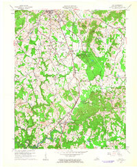
1961 Map of Lily
USGS Topo · Published 1963About this map
Levi Jackson Wilderness Road State Park anchors the central landscape of this Laurel County survey, where the historic Wilderness Road meets the Little Laurel River. The map captures the region during a period of transition, showing the expansion of London to the north, including Sue Bennett College and the London Municipal Airport. Further south, the rural economy is evident through numerous Strip Mines and the infrastructure of the Louisville and Nashville Railroad which services settlements like Fariston and Lily.
Find a feature on this map
58 named features on this map. Tap any name to fly to it.
Don’t see what you’re looking for? This feature index may not catch every label — zoom into the map to look around manually.
Map Details
Editions of this 1961 Lily Map
This is the sole edition of this map. No revisions or reprints were ever made.
Other maps of this area

1886 · Cumberland Gap
USGS Topo · 1:125,000

1888 · Cumberland Gap
USGS Topo · 1:125,000

1890 · Williamsburg
USGS Topo · 1:125,000

1891 · Manchester
USGS Topo · 1:125,000

1891 · Cumberland Gap
USGS Topo · 1:125,000

1893 · London
USGS Topo · 1:125,000

1894 · Williamsburg
USGS Topo · 1:125,000

1897 · London
USGS Topo · 1:125,000

1952 · Portersburg
USGS Topo · 1:24,000

1952 · Corbin
USGS Topo · 1:24,000