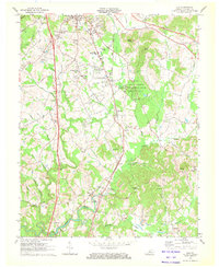
1970 Map of Lily
USGS Topo · Published 1972About this map
The Louisville and Nashville railroad and the historic Wilderness Road corridors anchor this 1970 landscape, illustrating the evolution of transport through Laurel County. The southern edge of London shows significant development, including Sue Bennett College and the London-Corbin War Memorial Airport. Central to the map is the Levi Jackson Wilderness Road State Park, preserving a section of the pioneer trail. Outside these developed hubs, the map documents a shift toward heavy industry with numerous Strip Mines appearing near Lily and along the Laurel River. Local genealogy is well-represented through family-named landmarks like McHargue and Brock, alongside scattered country churches such as Corinth Ch and Gilbert Chapel. The terrain is marked by the distinct elevations of Frazier Knob and Rocky Knob, which overlook the winding tributaries of Robinson Creek.
Find a feature on this map
65 named features on this map. Tap any name to fly to it.
Don’t see what you’re looking for? This feature index may not catch every label — zoom into the map to look around manually.
Map Details
Editions of this 1970 Lily Map
This is the sole edition of this map. No revisions or reprints were ever made.
Other maps of this area

1886 · Cumberland Gap
USGS Topo · 1:125,000

1888 · Cumberland Gap
USGS Topo · 1:125,000

1890 · Williamsburg
USGS Topo · 1:125,000

1891 · Manchester
USGS Topo · 1:125,000

1891 · Cumberland Gap
USGS Topo · 1:125,000

1893 · London
USGS Topo · 1:125,000

1894 · Williamsburg
USGS Topo · 1:125,000

1897 · London
USGS Topo · 1:125,000

1952 · Portersburg
USGS Topo · 1:24,000

1952 · Corbin
USGS Topo · 1:24,000