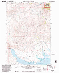
1997 Map of Lima Dam
USGS Topo · Published 2002About this map
Lima Reservoir dominates the southern reaches of this landscape, its expansive waters contained by the Lima Dam Spillway 6577. Situated within the Centennial Valley of Beaverhead County, this 1997 revision highlights a transition from high-altitude desert basin to the steep elevations of the Clover Divide. The hydrologic network here is central to the area's utility, with the Red Rock River feeding the reservoir and a Gaging Sta monitoring the flows essential for downstream ranching. To the north, the terrain rises into the Beaverhead National Forest, where numerous drainages like Blacktail Deer Creek and Clover Creek carve through the high country. This document serves as a critical record of water management and forest boundaries in the Montana backcountry, detailing the remote Trail systems and spring-fed creeks that define the region's geography.
Find a feature on this map
18 named features on this map. Tap any name to fly to it.
Don’t see what you’re looking for? This feature index may not catch every label — zoom into the map to look around manually.
Map Details
Editions of this 1997 Lima Dam Map
This is the sole edition of this map. No revisions or reprints were ever made.
Other maps of this area

1955 · Dubois
USGS Topo · 1:250,000

1958 · Dubois
USGS Topo · 1:250,000

1968 · Corral Creek
USGS Topo · 1:24,000

1968 · Whiskey Spring
USGS Topo · 1:24,000

1968 · Lima Dam
USGS Topo · 1:24,000

1968 · Snowline
USGS Topo · 1:24,000

1968 · Vinegar Hill
USGS Topo · 1:24,000

1968 · Monida
USGS Topo · 1:24,000

1968 · Henry Gulch
USGS Topo · 1:24,000

1968 · Antone Peak
USGS Topo · 1:24,000