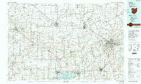
1986 Map of Lima
USGS Topo · Published 1992About this map
Lima serves as the primary urban anchor for this region during the mid-1980s, a landscape defined by an extensive rail network and significant agricultural and industrial infrastructure. The city's growth is evidenced by the Ohio State Univ Lima Campus and the Lima Ordnance Modification Center. To the south, the massive Grand Lake-St Marys and its accompanying Grand Lake-St Marys State Park dominate the border of Mercer and Auglaize counties. The map captures the industrial character of the era through several regional hubs like Van Wert, Delphos, and Decatur, all connected by a web of historic rail lines including the Norfolk and Western RR and the Baltimore and Ohio RR. Small settlements like Willshire and Rockford follow the winding course of the St Marys River, illustrating the older patterns of river-valley settlement that persist alongside modern transportation corridors.
Find a feature on this map
125 named features on this map. Tap any name to fly to it.
Don’t see what you’re looking for? This feature index may not catch every label — zoom into the map to look around manually.
Map Details
Editions of this 1986 Lima Map
3 editions found
Other maps of this area

1906 · Lima
USGS Topo · 1:62,500

1906 · Columbus Grove
USGS Topo · 1:62,500

1907 · Bluffton
USGS Topo · 1:62,500

1908 · Columbus Grove
USGS Topo · 1:62,500

1908 · Ottawa
USGS Topo · 1:62,500

1908 · St. Henry
USGS Topo · 1:62,500

1909 · Continental
USGS Topo · 1:62,500

1909 · Loramie
USGS Topo · 1:62,500

1911 · Berne
USGS Topo · 1:48,000

1911 · Loramie
USGS Topo · 1:62,500