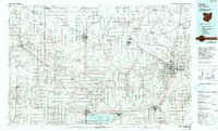
1986 Map of Lima
USGS Topo · Published 1992About this map
The Auglaize River and St Marys River systems anchor this West-Central Ohio and East-Indiana borderland, where drainage patterns define the agricultural landscape. The region's industrial and social infrastructure is well-marked, including the Lima Ordnance Modification Center and Lima State Hospital. Higher education and specialized facilities are prominent, with the Ohio State Univ Lima Campus and Lima Technical College serving as regional hubs. Local history is preserved through numerous rural burial grounds such as St Josephs Cemetery and Woodland Cemetery, while the economy is reflected in the extensive rail network of the Baltimore and Ohio RR and Norfolk and Western RR. Recreational and conservation interests are represented by the expansive Grand Lake-St Marys State Park and the St Marys State Fish Farm at the southern edge of the survey.
Find a feature on this map
216 named features on this map. Tap any name to fly to it.
Don’t see what you’re looking for? This feature index may not catch every label — zoom into the map to look around manually.
Map Details
Editions of this 1986 Lima Map
3 editions found
Other maps of this area

1906 · Lima
USGS Topo · 1:62,500

1906 · Columbus Grove
USGS Topo · 1:62,500

1907 · Bluffton
USGS Topo · 1:62,500

1908 · Columbus Grove
USGS Topo · 1:62,500

1908 · Ottawa
USGS Topo · 1:62,500

1908 · St. Henry
USGS Topo · 1:62,500

1909 · Continental
USGS Topo · 1:62,500

1909 · Loramie
USGS Topo · 1:62,500

1911 · Berne
USGS Topo · 1:48,000

1911 · Loramie
USGS Topo · 1:62,500