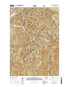
2017 Map of Limber Jim Creek
USGS Topo · Published 2017About this map
Whitman National Forest land defines this corner of Union County, where high-elevation drainages converge to form the headwaters of major regional waterways. The Grande Ronde River and its upper tributaries, including Limber Jim Creek and the E Fork Grande Ronde River, carve through the landscape, creating a network of ridges and meadows. Key geographic features such as Limber Jim Ridge and the broad opening of Limber Jim Meadow illustrate the characteristic high-country terrain. Small, specialized water resources are evident at Rainbow Reservoirs and the isolated Erickson Lake. The map details an extensive system of forest development roads, such as Nat For Dev Rd 100 and Nat For Dev Rd 51, which provide access to these remote reaches. From the depths of Deadwood Gulch to the seasonal wetlands of Round Meadow, the map captures the complex hydrology and management of this timbered mountain environment.
Find a feature on this map
31 named features on this map. Tap any name to fly to it.
Don’t see what you’re looking for? This feature index may not catch every label — zoom into the map to look around manually.
Map Details
Editions of this 2017 Limber Jim Creek Map
This is the sole edition of this map. No revisions or reprints were ever made.
Other maps of this area

1901 · Sumpter
USGS Topo · 1:125,000

1953 · Pendleton
USGS Topo · 1:250,000

1955 · Canyon City
USGS Topo · 1:250,000

1956 · Pendleton
USGS Topo · 1:250,000

1959 · Canyon City
USGS Topo · 1:250,000

1965 · Limber Jim Creek
USGS Topo · 1:24,000

1965 · Marley Creek
USGS Topo · 1:24,000

1965 · Anthony Butte
USGS Topo · 1:24,000

1965 · Little Beaver Creek
USGS Topo · 1:24,000
1965 · La Grande Reservoir
USGS Topo · 1:24,000