
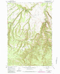
1965 Map of Marley Creek
USGS Topo · Published 1967About this map
Starkey and Camp Elkanah occupy the northern reaches of this mid-1960s survey, where the Grande Ronde River and Meadow Creek converge. The landscape is dominated by the Starkey Experimental Forest and Range and the Whitman National Forest, reflecting a region dedicated to forestry and watershed management. A distinctive legacy of earlier industry is visible in the Old Railroad Grade winding through the northern valley, once a vital link for timber extraction that now follows the contours of the creek. Numerous water sources, such as McCarty Spring, Coon Spring, and Pickle Spring, are scattered across the high ridges, including Whitehorse Ridge. The presence of the Johnson Rock Lookout Tower at the southern edge suggests the critical role of fire observation in this heavily timbered terrain.
Find a feature on this map
32 named features on this map. Tap any name to fly to it.
Don’t see what you’re looking for? This feature index may not catch every label — zoom into the map to look around manually.
Map Details
Editions of this 1965 Marley Creek Map
2 editions found
Other maps of this area

1953 · Pendleton
USGS Topo · 1:250,000

1956 · Pendleton
USGS Topo · 1:250,000

1964 · Mc Intyre Creek
USGS Topo · 1:24,000

1964 · Kamela SE
USGS Topo · 1:24,000

1965 · Limber Jim Creek
USGS Topo · 1:24,000

1965 · Little Beaver Creek
USGS Topo · 1:24,000

1965 · Fly Valley
USGS Topo · 1:24,000

1967 · Tower Mtn
USGS Topo · 1:24,000

1967 · Sullivan Gulch
USGS Topo · 1:24,000

1967 · Bally Mountain
USGS Topo · 1:24,000