
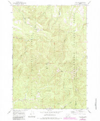
1967 Map of Tower Mtn
USGS Topo · Published 1969About this map
Tower Mtn stands as a central topographic anchor in this late-1960s survey, crowned by a Lookout Tower that surveys the surrounding high-altitude drainage systems. The landscape is defined by the convergence of the Umatilla National Forest and Whitman National Forest, where steep drainages such as Cable Creek and Fly Creek carve through the timber. Unlike more developed lowland areas, human activity here is centered on forest management and seasonal occupancy, evidenced by Wapiti Camp and a network of Pack Trails and Jeep Trails.
Find a feature on this map
25 named features on this map. Tap any name to fly to it.
Don’t see what you’re looking for? This feature index may not catch every label — zoom into the map to look around manually.
Map Details
Editions of this 1967 Tower Mtn Map
2 editions found
Other maps of this area

1901 · Sumpter
USGS Topo · 1:125,000

1951 · Desolation Butte
USGS Topo · 1:62,500

1953 · Pendleton
USGS Topo · 1:250,000

1955 · Canyon City
USGS Topo · 1:250,000

1956 · Pendleton
USGS Topo · 1:250,000

1959 · Canyon City
USGS Topo · 1:250,000

1965 · Marley Creek
USGS Topo · 1:24,000

1965 · Fly Valley
USGS Topo · 1:24,000

1967 · Sullivan Gulch
USGS Topo · 1:24,000

1967 · Lehman Springs
USGS Topo · 1:24,000