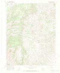
1967 Map of Lime Creek
USGS Topo · Published 1970About this map
Rio Grande National Forest dominates this high-altitude Saguache County landscape, where the drainage networks of Biedell Creek and Lime Creek carve through the terrain. The 1967 survey reveals a working wilderness, evidenced by a designated Stock Driveway and numerous mines and prospects scattered across the eastern slopes near Sanderson Gulch. The resource-driven economy of the era is further marked by a network of jeep trails providing access to isolated points like San Juan Trail Spring and the upper reaches of Poison Gulch. In the northern section, the topography falls away toward Red Rock Canyon and Fullerton Creek, illustrating the complex watershed system that feeds into North Fork Carnero Creek. This map is a record of mid-century land management, balancing industrial interest with the vast public lands of the National Forest system.
Find a feature on this map
20 named features on this map. Tap any name to fly to it.
Don’t see what you’re looking for? This feature index may not catch every label — zoom into the map to look around manually.
Map Details
Editions of this 1967 Lime Creek Map
3 editions found
Other maps of this area

1915 · Del Norte
USGS Topo · 1:125,000

1917 · Del Norte
USGS Topo · 1:125,000

1945 · Durango
USGS Topo · 1:250,000

1953 · Durango
USGS Topo · 1:250,000

1954 · Durango
USGS Topo · 1:250,000

1956 · Montrose
USGS Topo · 1:250,000

1959 · Montrose
USGS Topo · 1:250,000

1960 · Montrose
USGS Topo · 1:250,000

1961 · Durango
USGS Topo · 1:250,000

1963 · Durango
USGS Topo · 1:250,000