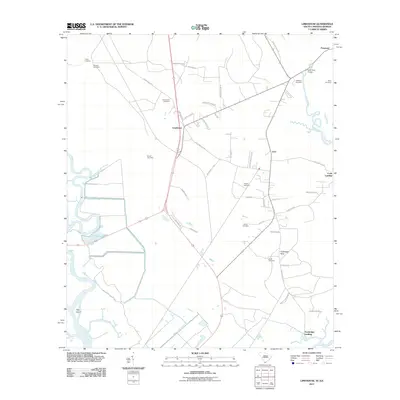
2011 Map of Limehouse
USGS Topo · Published 2011About this map
The New River and its surrounding wetlands define this landscape near the South Carolina and Georgia border, where the settlement of Limehouse sits at the intersection of several local routes. The area is marked by a deep genealogical record, evidenced by numerous family and community burial grounds including Chisolm Cemetery, Garret Cemetery, and Hardy Cemetery. Waterways dominate the western and southern reaches, from the winding Back River and Clydesdale Creek to the engineered Murray Hill Canal and Lucknow Canal, reflecting a coastal geography shaped by both natural tides and historic drainage efforts. To the east, the New River Bridge connects the terrain near Levy, while isolated points like Union Landing and Turnbridge Landing trace the edges of the river system. The presence of Hog Island and the broad Tunbridge Neck further illustrates the complex interface of land and water in this lowcountry region.
Find a feature on this map
53 named features on this map. Tap any name to fly to it.
Don’t see what you’re looking for? This feature index may not catch every label — zoom into the map to look around manually.
Map Details
Editions of this 2011 Limehouse Map
This is the sole edition of this map. No revisions or reprints were ever made.
Other maps of this area

1920 · Hardeeville
USGS Topo · 1:62,500

1920 · Okatie
USGS Topo · 1:62,500

1920 · Bluffton
USGS Topo · 1:62,500

1942 · Savannah
USGS Topo · 1:62,500

1942 · Okatie
USGS Topo · 1:62,500

1943 · Hardeeville
USGS Topo · 1:62,500

1945 · Bluffton
USGS Topo · 1:62,500

1947 · Savannah
USGS Topo · 1:250,000

1948 · Savannah
USGS Topo · 1:250,000

1953 · Hardeeville
USGS Topo · 1:62,500